
At 36,000 feet above the Arabian Sea, an Airbus A350 is cruising peacefully when, suddenly, an alarm screams in the cockpit: "Pull up, Pull up!" Yet there is no terrain ahead of the aircraft, everything is fine, and nobody panics.
The pilots know it is not a malfunction. They even know the area is notorious for this kind of episode, ever since their electronic flight bag flagged it on the chart a few minutes earlier.
Apart from the pilots and the airline's ground staff, no one not even the 300 passengers in the back will ever hear about it.
So what is actually going on?
An alarm that is not one
By 2018, more than a third of the air traffic crossing European skies was already passing through "questionable" zones, six years before the word spoofingGPS Spoofing
A technique in which a ground transmitter broadcasts fake satellite signals more powerful than the real ones to make an aircraft's GPS receiver believe it is in a fictitious position, without triggering any alarm. forced its way into the international press. By 2024, around 1,500 flights per day were flying with a position the aircraft took for granted but the pilots knew might be false (OpsGroupOpsGroup
International organisation of professional pilots and dispatchers, founded in 2013. Publishes real-time operational safety alerts, including the reference report on GPS spoofing (September 2024). More than 10,000 members from 150 airlines. GPS Spoofing Final Report, September 2024). Between 15 July and 15 August of that same year alone, some 41,000 flights crossed an episode of falsified satellite signal (IATAIATA International Air Transport Association
International organisation representing 300 airlines (83% of global air traffic). Publishes annual safety reports. Headquartered in Geneva. Annual Safety Report 2025). The passengers heard nothing about it. Nothing in the international regulatory architecture compels anyone to tell them, and the industry, which knows the numbers, has every reason to keep them inside the cockpit.
JammingGPS Jamming
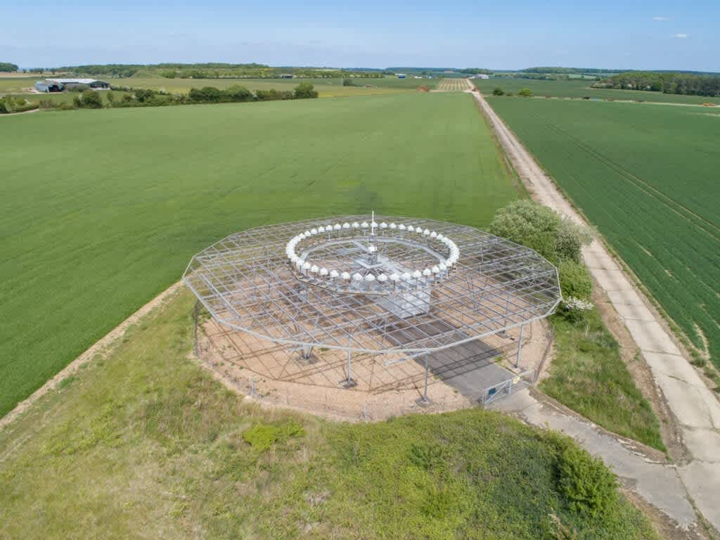
A parasitic transmitter floods satellite navigation frequencies with noise, deafening the aircraft's receiver. The crew is alerted instantly and switches to backup systems (VOR, ILS, inertial). Unlike spoofing, jamming triggers an immediate warning. is as old as electronic warfare itself: a parasitic transmitter floods the satellite navigation frequencies with noise, the aircraft's receiver is deafened and can no longer pick up the faint signals raining down from above, the crew is alerted instantly and falls back on backup systems (VORVOR VHF Omnidirectional Range
Ground-based radio navigation aid. Broadcasts a signal in all directions, allowing an aircraft to determine its bearing from the station. Works independently of GPS; primary backup during jamming or spoofing events., ILSILS Instrument Landing System
Radio system guiding aircraft on approach. Provides lateral (localizer) and vertical (glide slope) guidance. Operates on frequencies unaffected by GPS spoofing., inertial). It is documented, managed, relatively well tolerated treated as a fact of life, on much the same footing as turbulence.
Spoofing is a different beast. A ground transmitter generates fake signals that flawlessly mimic the satellites' signature, with greater power and precise timing. The receiver does exactly what it was designed to do: it locks onto the cleanest, loudest, sharpest and therefore most credible signal. It can thus be virtually teleported to a wholly false position, tens, hundreds, even thousands of kilometres from reality. And it does so without setting off the slightest alarm, because the error, from the system's strictly logical standpoint, remains perfectly consistent.
No alarm, then, because the system is convinced there is nothing to report.
This reversal "credible deception" rather than visible loss is what makes the whole thing so awkward. Mark PsiakiMark PsiakiResearcher, Virginia TechProfessor of aerospace engineering, specialist in satellite navigation and GNSS spoofing detection. Co-author with Todd Humphreys of the seminal 2016 paper published in the Proceedings of the IEEE. and Todd HumphreysTodd HumphreysProfessor, University of Texas at AustinRadio-navigation researcher and pioneer of the practical GPS spoofing demonstration on a luxury yacht (2013). His work is considered foundational in civilian GNSS vulnerability research., who co-authored the seminal 2016 paper on the subject, demonstrated that a standard civilian receiver can be captured and steered toward a fictitious position without ever losing its lock on the signals. Everything turns on the gap between an aircraft that knows it is blind and an aircraft that does not know it is seeing wrong. The second situation is particularly attractive to anyone who wants to do harm without leaving fingerprints.
A decade after their foundational paper, Psiaki and Humphreys observed that, despite ten years of academic interest, no commercial civilian receiver knew how to defend itself against a state-level attack. The line has aged better than most of the equipment it described.
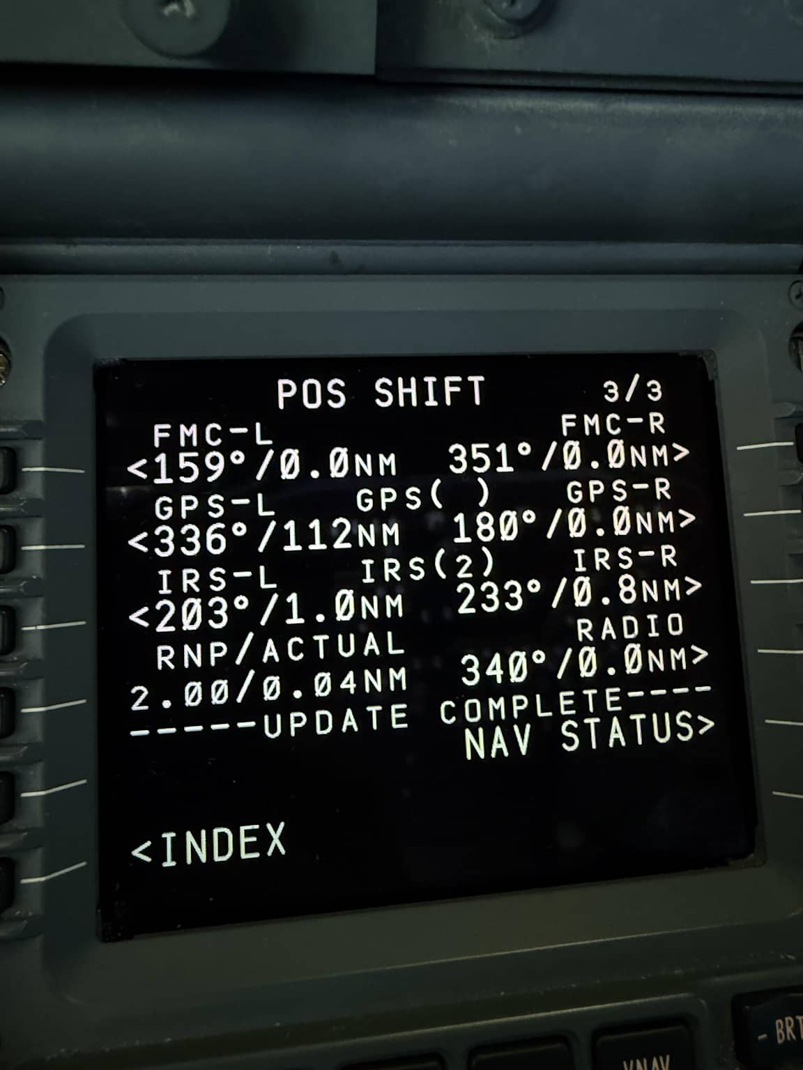
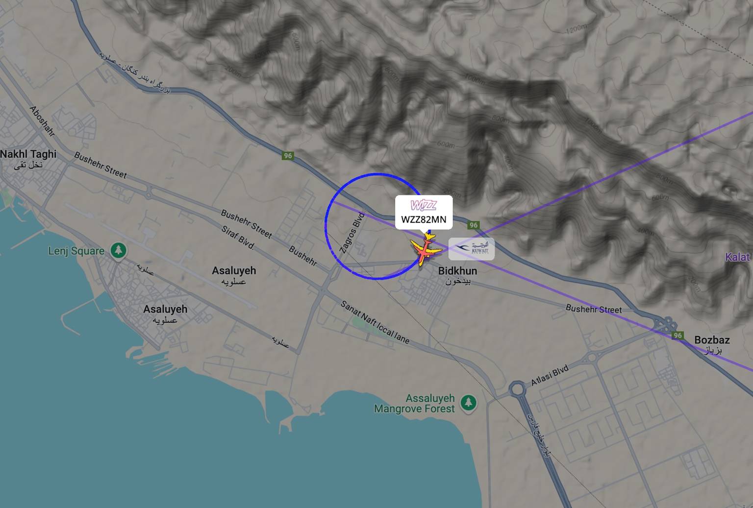
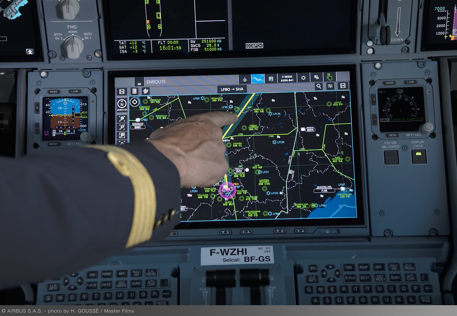
The onboard computer that calculates and monitors the flight route. It uses GPS, IRS, and radioaltimeter data to determine the aircraft's position. position shift as captured on tracking software: the aircraft is shown in circles where the spoofed signal places it far from its actual route.© Reddit / r/aviation, anonymous
Disabling a safety system, for safety reasons
The EGPWSEGPWS Enhanced Ground Proximity Warning System
Terrain proximity warning system. Continuously calculates, using GPS, the radio altimeter and terrain data, whether the aircraft risks hitting the ground or high terrain. Emits an audible "Pull up" alarm if a collision is detected. is meant to scream when an aircraft strays too close to terrain. Drawing on GPSGPS Global Positioning System
American satellite navigation system (24+ satellites). Allows position to be determined with metre-level accuracy. Its civilian version is unencrypted and therefore vulnerable to spoofing., the radioaltimeterRadio altimeter
Instrument that physically measures the aircraft's height above the terrain by bouncing a radio wave off the ground. Operates independently of GPS: it cannot be spoofed, since it measures a physical distance rather than receiving an external signal. and terrain data, it continuously calculates whether the aircraft is at risk of hitting something. If the GPS is hallucinating, the EGPWS plays along. Crews end up pulling up sharply over a perfectly flat sea, or in the opposite case hearing nothing at all during an approach that is in fact going badly wrong. Both situations are dangerous for opposite reasons: one wears down pilots' trust in real alarms; the other destroys it.
The operational answer, in some airlines, is to pre-emptively disable the EGPWS's advanced modes before entering the most exposed zones. At Air FranceThe list of nine airports concerned was disclosed by industry sources in 2024–2025, including Beirut, Dubai, Mumbai, Delhi, Tel Aviv and Cairo., for instance, nine airports are subject to this procedure, including Beirut, Dubai, Mumbai, Delhi, Tel Aviv and Cairo. The list reads less like a procedural manual than like a map of the planet's exposed nerves. Compensating measures are in place: enhanced cross-checking of radioaltimeters, descent-rate restrictions, no night visual approaches.
A choice has therefore been made between two risks, in a sky where the signal that was supposed to hold everything else together has, in some places, turned capricious. Other airlines wrestle with the same problem using their own recipes, more or less openly. The underlying logic is the same: when the ground lies, you start by silencing whoever is crying wolf and then you reinvent how to listen to the terrain.
Professionals whose entire training rests on the reliability of onboard systems have had to design a procedure for disabling a crash-protection system in order to avoid a crash caused by that very system. The Chicago Convention of 1944 contained no annex for this particular case.
The latest A350s, fitted with automatic re-initialisation systems after exposure to interference zones, have since been partially exempted from the procedure. Older airframes, less protected, remain bound by it. The world fleet does not move at the same speed as the threats.
The geography of deception
The map of disturbances does not look like a random scatter of dots. It hugs the fault lines of the moment fairly tightly: Eastern Europe, the Levant–Gulf corridor, the India–Pakistan border.
The Baltic arc. Since 2017, electronic-warfare systems based in KaliningradKaliningrad
Russian exclave on the Baltic Sea, bordered by Poland and Lithuania. Home to important electronic-warfare installations whose interference regularly affects Finnish, Estonian, Latvian, Lithuanian and Polish airspace. and on the Kola peninsula have been jamming Finnish, Estonian, Latvian and Lithuanian airspace on a daily basis.
In August 2025, the aircraft carrying European Commission President Ursula von der LeyenUrsula von der LeyenPresident of the European CommissionGerman politician born in 1958, former Defence Minister (2013–2019). President of the European Commission since December 2019, re-elected in July 2024. Her aircraft lost its GPS signal on approach to Plovdiv (Bulgaria) in August 2025. on approach to Plovdiv, Bulgaria, lost its GPS at the worst possible moment: backup procedures, holding patterns and, according to several sources, a return to paper charts before landing on ILSILS Instrument Landing System
Ground system guiding aircraft on approach via lateral and vertical radio guidance. Unaffected by GPS spoofing.. The event made headlines because the passenger was important. The same symptoms, on anonymous flights, occur hundreds of times a month without leaving the "technical" pages.
In October 2025, the ICAOICAO International Civil Aviation Organisation
Specialised UN agency created by the Chicago Convention (1944). Sets global aviation safety standards through technical annexes. Headquartered in Montreal. 193 member states. Assembly labelled Russian and North Korean interference an "infringement" of the Chicago Convention. That was the strongest verb available in the organisation's dictionary. The next day, Russia went on jamming the Baltic arc as before, because no article in the Convention allows anyone to ask it for anything beyond a polite request to stop.
A Russian transmitter in Kaliningrad operates on Russian sovereign soil. The disturbances it sends across Estonian, Finnish, Polish or Swedish airspace are framed as the collateral effects of a "domestic" activity. The Chicago Convention thus ends up shielding the state that jams its neighbours in the name of its own sovereignty even though it was originally drafted to protect aviation from that same state.
The researcher Tegg WestbrookTegg WestbrookAviation security researcherAnalyst specialising in electronic interference on civilian navigation systems. Author of a reference study on aircraft vulnerability to politically motivated radio-frequency interference in Eastern Europe, published in Security and Defence Quarterly (2024). has dissected this theatre. He distinguishes three ways of using such interference: feeding a narrative of Western aggression with manipulated signals, complicating the economics of certain corridors, and maintaining ambiguity about what Russian systems can actually do. The three rationales coexist comfortably. They are not necessarily the product of a master plan; they are simply convenient at several levels at once.
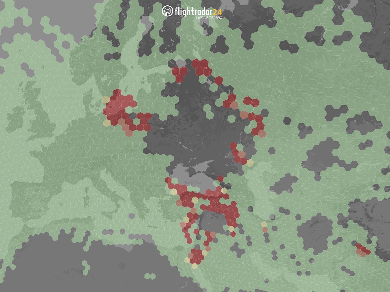
Swedish flight-tracking platform aggregating ADS-B, MLAT and radar data from a global network of receivers. One of the main public sources for monitoring GPS interference. GPS Jamming Map: in red, areas of heavy interference across Europe. Ukraine shown in black no civilian data available.© Flightradar24 AB, blog.flightradar24.com
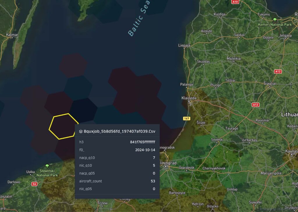
Generic term covering all satellite navigation constellations: GPS (US), Galileo (EU), GLONASS (Russia), BeiDou (China). Modern aircraft use signals from several simultaneously. interference mapped by Spire GlobalSpire GlobalUS satellite data companySpire Global operates a constellation of small satellites measuring atmospheric, weather and GPS signal conditions. Their interference reports are used by aviation regulators and researchers. off Kaliningrad, October 2024: dark hexagons mark areas where more than half of aircraft report degraded signal.© Spire Global, spire.com
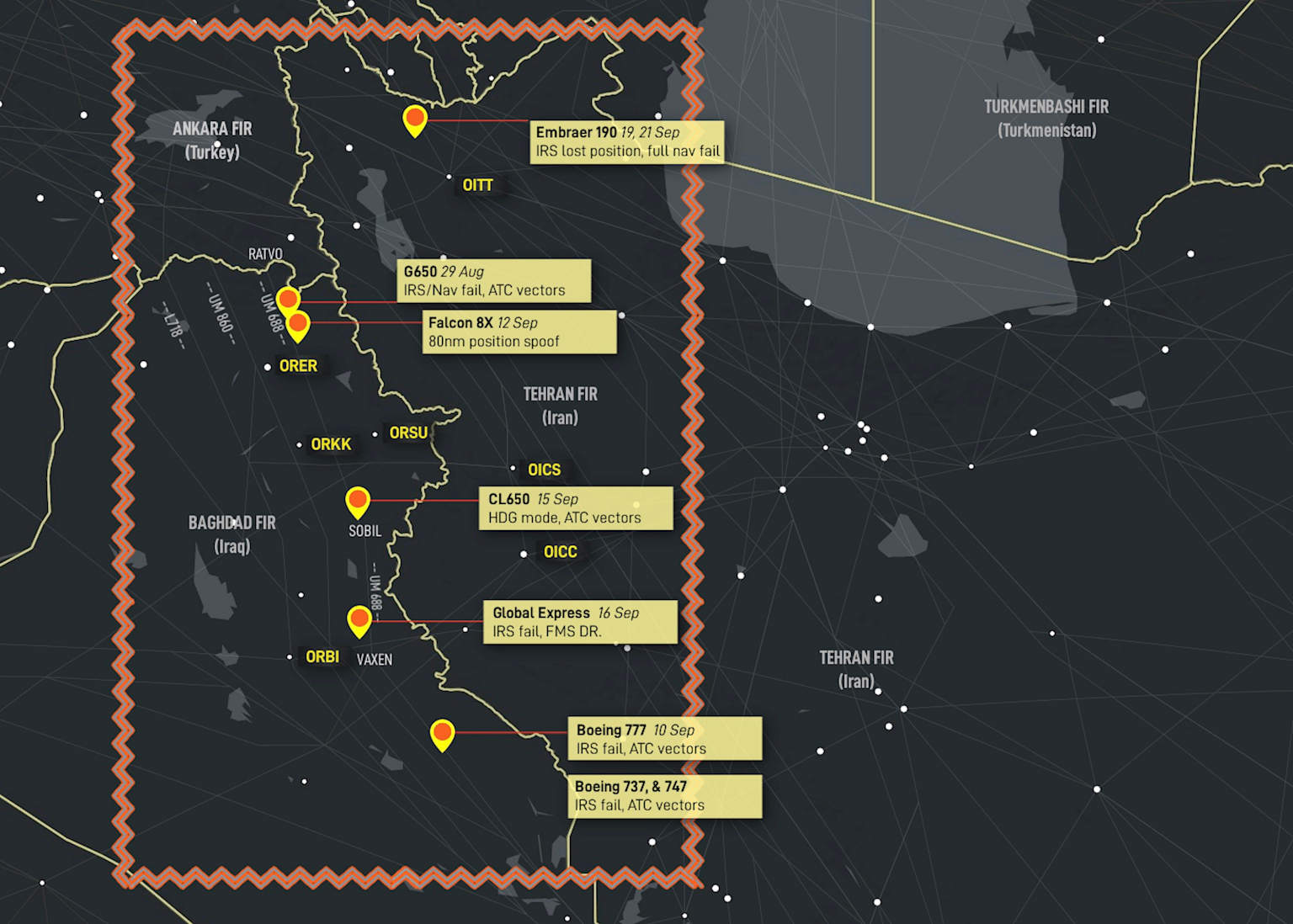
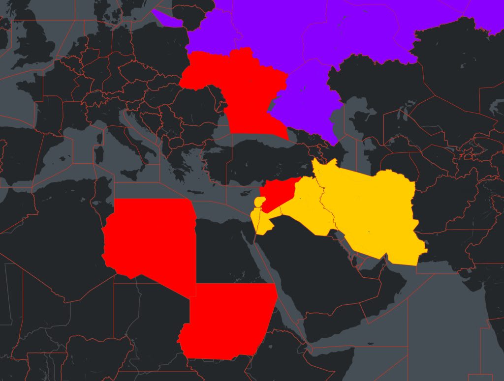
In the Middle East the scenery is different, and rather more worrying for civilian flights. Israel began spoofing GPS to throw off drones and guided missiles coming in from Lebanon, Gaza or Iran. Iran, for its part, jams American surveillance assets over the Gulf. These transmitters do not bother to tell an MQ-9 Reaper from an A320 full of tourists and, more to the point, no one has instructed them to. Since late 2023, several dozen serious navigation incidents have been logged around Baghdad, Cairo and Tel Aviv.
In late February 2026, after the strikes on Iran's nuclear facilities, seven airspaces were closed or restricted in cascade: Iran, Iraq, Israel, Bahrain, Kuwait, Qatar, the United Arab Emirates. More than 5,000 flights vanished from flight plans within hours. The Europe–Asia corridor, already on edge, twisted in on itself.
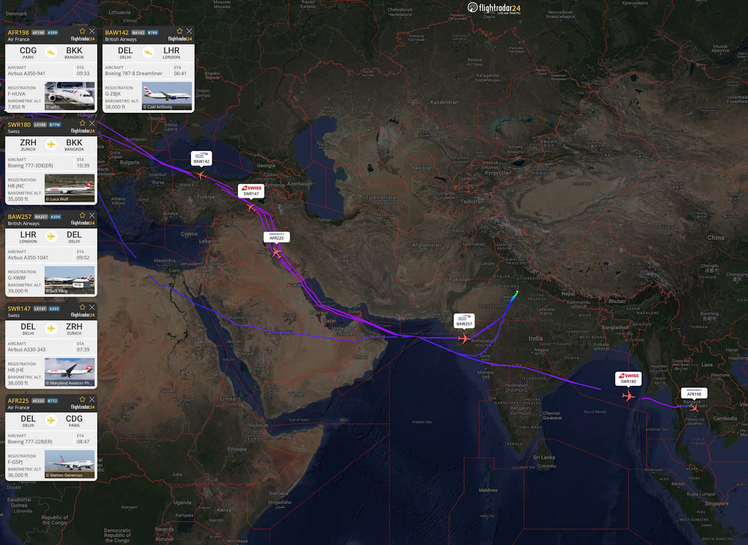
Further east, India and Pakistan offer another textbook case. On 22 April 2025, the PahalgamPahalgam attack (22 April 2025)
Terrorist attack in Indian-administered Kashmir that killed 26 tourists. Triggered a serious Indo-Pakistani diplomatic and military crisis, leading to the reciprocal closure of both national airspaces from 24 April 2025. attack in Kashmir triggered a reciprocal closure of national airspaces, extended at least until March 2026. The Paris–Delhi, Paris–Bangkok and Paris–Ho Chi Minh routes added several dozen minutes to each rotation. For Air India alone, an internal letter to the Indian government, leaked to Reuters in April 2025, estimated the additional cost at roughly 600 million dollars a yearSource: Reuters, 25 April 2025. Air India letter to the Indian Ministry of Civil Aviation. Estimate based on a prolonged closure of Pakistani airspace., assuming a prolonged closure.
Spoofing is not the cause of the crisis, but it forms a permanent background hum: in this kind of high-tension airspace, radio interference layers itself on top of administrative decisions, and crews work in an environment where neither position nor corridor is guaranteed from one hour to the next.
If you pull up FlightRadar24FlightRadar24
Swedish real-time air traffic tracking platform. Has developed a separate GPS jamming map, updated continuously. on an ordinary day, the world traffic map now shows recurring holes: Syria, Lebanon, Israel, Iraq, Iran, parts of Ukraine, Pakistan. These are not merely "high-risk" areas. For many operators, they are officially closed, strongly inadvisable, or open only along a handful of residual corridors. Aviation there is not impossible, but it has become conditional: who you are, where you depart from and where you are headed determines whether you are still allowed through.
Swedish flight-tracking platform aggregating ADS-B, MLAT and radar data from a global network of receivers. MLATMLAT Multilateration
Position calculation by measuring the time difference between a signal received by several ground stations. Used as a backup when GPS is unreliable.: when GPS is no longer reliable, aircraft position is reconstructed by ground-based triangulation. The circle indicates location uncertainty.© Flightradar24 AB, blog.flightradar24.com
The professionals know
Brendan SobieBrendan SobieAviation consultantIndependent aviation consultant, formerly of CAPA Centre for Aviation. Widely cited in 2025 on the proliferation of airspace closures and their economic impact on airlines. Based in Singapore., an aviation consultant widely quoted in 2025, described the proliferation of airspace closures as "the new normal for airlines." The phrase is accurate, and that is precisely the problem. What becomes normal stops being debated, and what stops being debated eventually slips out of political reach.
In a 2024 OpsGroup survey, 70% of pilots flying the most exposed routes reported "very high" or "extreme" concern about GNSSGNSS Global Navigation Satellite System
Generic term for all satellite navigation systems: GPS (US), GLONASS (Russia), Galileo (EU), BeiDou (China). interference. Regulators know. The operations centres of major airlines know in real time. The zones are colour-coded on electronic flight bags, refreshed every seven minutes from data uplinked by aircraft already in the air, with jamming and spoofing distinguished. The EASAEASA European Union Aviation Safety Agency
EU aviation safety agency based in Cologne. Certifies civil aircraft, publishes airworthiness standards and safety bulletins. No binding regulatory power over non-EU states. platform broadcasts a map of active zones behind a credential reserved for accredited commercial operators. When a specialist who has worked on these tools since their inception talks about it, he does so with the calm of someone who has learned to live with a problem he can monitor but not solve:

Tegg WestbrookTegg WestbrookAviation security researcherAnalyst specialising in electronic interference on civilian navigation systems. Author of a reference study on aircraft vulnerability to politically motivated radio-frequency interference in Eastern Europe, published in Security and Defence Quarterly (2024)., in Security and Defence Quarterly, noted that the threat is "widespread, irregular, intermittent, and can occur at any time." Intermittence is always the hardest to manage. A permanent risk turns into a procedure. A risk that surfaces by surprise twice a month, in corridors flown daily, ends up producing something more dangerous than an alarm: the habit of no longer believing in it.
The investigation into Malaysia Airlines flight MH17Malaysia Airlines MH17
Boeing 777 shot down on 17 July 2014 over eastern Ukraine, killing all 298 people on board. The Dutch Safety Board attributed the crash to a BUK missile fired from Russian-controlled territory. The inquiry (Kuipers, Verolme, Muller, 2020) highlighted the failure of warning mechanisms to reach airlines in time., dissected by Kuipers, Verolme and Muller in 2020, had already laid bare the pattern: the warning signs existed, the channels to relay them to airlines did not, and the question of who should have spoken first remains, eleven years on, unanswered. The structure repeats itself today, identically with one difference: the disaster has not yet happened.
The von der Leyen incident received the kind of media coverage one would expect, while thousands of identical episodes on ordinary flights get no public communication at all. The argument is fairly logical and defensible: do not feed panic about a risk that, for now, remains contained. This economy of transparency has an intellectual cost, however. It prevents the formation of public opinion on a subject that is ultimately a matter of collective political choice. And it leaves untouched the question HumphreysTodd HumphreysProfessor, University of Texas at AustinRadio-navigation researcher, pioneer of the practical GPS spoofing demonstration on a luxury yacht (2013). His work is considered foundational in civilian GNSS vulnerability research. raised in his earliest work: satellite navigation was designed on the assumption of an honest signal. Once that assumption falls, the entire stack of technology no longer protects very much.
No one has crashed because of GPS spoofing. Not yet.
A treaty written for the wrong threat
The Chicago Convention, signed in 1944 by states emerging from a war in which civilian aircraft had been deliberately shot down, anticipated the state that brings down a foreign airliner. It did not anticipate the state that deceives it.
Annex 11 imposes on each contracting party an obligation of safety in its sovereign airspace. Annex 17, on the security side, deals with unlawful acts on airports and on board. In between, electronic interference emitted from the soil of state A and contaminating the airspace of state B falls into a zone the drafters could not foresee.
In 2025, the ICAO Assembly adopted a resolution explicitly identifying Russian and North Korean interference as contrary to the Convention. The text clarified the organisation's moral position but not its actual power. ICAOICAO International Civil Aviation Organisation
Specialised UN agency created by the Chicago Convention (1944). Sets global aviation safety standards. Headquartered in Montreal. 193 member states. Operates by consensus meaning states that cause problems also have a vote. operates by consensus among states that include those who would have to be sanctioned, which turns a safety problem into a question of internal diplomacy. The mechanism therefore keeps turning, with no one truly accountable for what it fails to deliver.
The tool also ticks every box of what strategy analysts call a gray-zone weaponGray-zone weapon
Military concept describing tools used below the threshold of declared conflict. Plausibly deniable, produces no spectacular images, crosses no immediate political threshold. Designed to manufacture effects without manufacturing corpses, keeping alliances from being obliged to react.. It is plausibly deniable: a state can claim it is simply protecting its own territory against drones. It produces no explosion and no spectacular images, crosses no immediate political threshold, and is technically attributable only with signal-analysis capabilities most civilian authorities do not possess. It manufactures effects without manufacturing corpses, which keeps it below the threshold at which alliances are obliged to react. In the strict sense, it is a weapon designed for a time when open war is too costly and inaction too visible.
Iran was already using it in 2019 to force merchant ships into its territorial waters, as investigations around the Stena ImperoStena Impero
British-flagged tanker seized by Iran's Revolutionary Guards in the Strait of Hormuz on 19 July 2019. Investigations established that GPS spoofing had been used to guide the vessel into Iranian territorial waters before boarding. The first documented case of GPS spoofing used as a geopolitical tool against a civilian vessel. established. The aim was not to sink those vessels, simply to move them. Transposing this to civil aviation requires no technical leap, only a political one and in places that leap has already been taken. The Ryanair flight forced down over Belarus in May 2021, with its bogus bomb scare meant to lay hands on a journalist, is the kinetic version of the same grammar.

Resilience, for those who can afford it
In May 2026, Air France announced an investment of around 44 million euros over three yearsSource: La Tribune, May 2026. Investment to fit first fourteen A350s by end-2026, then sixty Boeing 777s by end-2027, with Collins Aerospace MMR multi-mode receivers capable of processing L1 and L5 frequencies across multiple constellations. to fit, first, fourteen A350s by the end of 2026, then sixty Boeing 777s by the end of 2027, with Collins Aerospace MMRMMR Multi-Mode Receiver (Collins Aerospace)
Advanced avionics receiver capable of processing multiple GNSS frequencies (L1 and L5) and multiple constellations simultaneously. Significantly more resistant to spoofing attacks than single-frequency receivers. Requires full avionics certification before installation. units capable of processing the L1 and L5 frequencies across several constellations. The decision was framed as an avionics upgrade. In practice, a sovereign task protecting navigation is quietly being shifted onto airlines and their suppliers.
United, LufthansaUnited Airlines / Lufthansa
Major US and European carriers whose scale allows them to absorb the cost of MMR retrofits typically the equivalent of one quarter's revenue for a small fleet per aircraft certified. and a handful of comparable carriers will follow the same path because they can afford to. Gulf carriers, Indian-subcontinent operators and sub-Saharan African airlines which by sheer geographic accident fly the corridors with the highest spoofing density will not, because the certification cycle for an MMR retrofit costs roughly what a small fleet earns in a quarter.
A hierarchy of resilience is therefore taking shape. The least equipped aircraft are the ones flying the most exposed corridors. And, for now, no international text demands that this change.
SafranSafran
French aerospace and defence group. One of the three main global manufacturers of GNSS-protected avionics receivers alongside Collins Aerospace and Thales., Collins Aerospace and ThalesThales
French defence and electronics group. Manufactures GNSS receivers and anti-spoofing avionics solutions. One of the main beneficiaries of the current wave of airline equipment upgrades. have each built entire product lines around receiver protection. The DGACDGAC Direction générale de l'Aviation civile
French civil aviation authority, under the Ministry of Transport. Certifies French operators and aircraft. Its November 2024 Info Sécurité update recommends but does not mandate GPS position cross-checking in risk areas., in its November 2024 Info Sécurité update, recommends that crews verify the consistency of their position by conventional means in risk areas; it mandates no equipment, because no European or international authority has the legal basis to do so.
This return to ground-based aids VORVOR VHF Omnidirectional Range
Ground-based radio navigation aid working independently of GPS. The industry had planned to phase it out in favour of an all-satellite environment, but the spoofing threat has led to its retention as a backup., DMEDME Distance Measuring Equipment
Radio system providing aircraft with their exact distance from a ground station. Combined with VOR, allows position fixing without any GPS dependency., ILS which the industry had planned to phase out in favour of an all-satellite environment, looks less like a technical choice than an acknowledgement: the system was built on the assumption of a neutral electromagnetic sky. That sky is no longer neutral. The only way to neutralise this kind of infrastructure would be to send a missile its way, which changes the nature of the problem.
We have, then, found the answer to the old question of who acts when the state cannot or will not. Industry will act. Public regulation, for its part, will know how to write a post-mortem.
Norms reform under pressure
A state seen as credible (the Netherlands, Switzerland…) will be put in charge of the inquiry. The state implicated will contest it. The international procedure will produce a technically very robust report, whose political conclusions will have been filtered several times before reaching the table of states. The window for tightening norms will open for a few months, then close. This is not only cynicism; it is how a system behaves when it dislikes admitting that it must change its rules.
The silent privatisation of resilience
Privatised resilience becomes the default regime. The major Western and Gulf carriers are kitting out their fleets, makers of hardened receivers are consolidating a multi-billion-dollar market, and the coexistence of protected fleets with exposed ones is shifting from anomaly to norm. ICAO continues to publish texts that say what ought to be done, without being able to compel those who cause the problem to comply. The system moves forward, but at multiple speeds.
Airspace closures as a quarterly habit
The Europe–Asia corridor will see further bursts of simultaneous closures involving five to seven airspaces no longer as exceptions but as a quarterly fixture. Diversions and reroutings, already running into the billions for Indian carriers alone, will eventually generate pressure in the opposite direction: it will no longer be the authorities explaining to airlines what they must accept, but the airlines, invoice in hand, demanding that someone finally do something other than map the problem.
Slow spoofing
A brutal spoof one that teleports an aircraft from Saudi Arabia to South America on the screen has little chance of fooling the systems for long: the gap is too large, and the flight computers eventually discard the GPS data. A slow spoof, on the other hand one that starts from the true position and shifts it by a few metres per minute could, if well crafted, cause an aircraft to miss a runway, nibble across a border, or drift into restricted airspace without any system raising a flag. A foggy day, a destroyed ground aid, a silenced VOR or ILS, no beacon left to cross-check the trajectory, and a clean but lying GNSS signal that walks the aircraft all the way to a threshold that is not the right one.
Ground-based radio navigation beacon emitting a signal in all directions. An aircraft equipped with a VOR receiver can determine its exact bearing from the beacon. Predates GPS and is independent of it. beacon on the ground: the navigation aid the industry had planned to retire, now being pulled back out as Plan B.© MakeUseOf / editorial use
What can happen, and what does not move
Civil aviation has been built on a culture of accident prevention through anticipation of risks, fed by real disasters, opened black boxes and chains of error reconstructed to the point of obsession. What it has not yet really integrated is the management of a durable, deliberate threat whose objective is not to destroy an aircraft, but to wear out a system to force it to live permanently on the edge of a risk it does not entirely control.
No one has crashed because of GPS spoofing. Not yet. And for some years now, that sentence has carried an expiry date no one knows for sure.
- IATAIATA International Air Transport Association Annual Safety Report 2025.
- OpsGroup, GPS Spoofing Final Report, September 2024.
- EASAEASA European Union Aviation Safety Agency/IATAIATA International Air Transport Association, GNSS Mitigation Plan, June 2025.
- ICAO, State of Global Aviation Safety 2025.
- ICAO, Assembly Resolution A42, October 2025.
- DGAC, Info Sécurité GNSS, November 2024.
- FlightRadar24, traffic data 2025–2026.
- Westbrook, Tegg. "Aircraft Vulnerability to Politically Motivated RFI in Eastern Europe". Security and Defence Quarterly, 2024.
- Kuipers, Verolme, Muller. "Lessons from the MH17 Transboundary Disaster Investigation", 2020.
- Psiaki & Humphreys. "GNSS Spoofing and Detection". Proceedings of the IEEE, 2016.
- Todd Humphreys, IEEE Spectrum, December 2024.
- La Tribune, May 2026, Air France anti-spoofing investment.
- Reuters, 25 April 2025, Air India letter to the Indian Ministry of Civil Aviation.
- Airline professional interview, May 2026.